Tornadoes touch down a day after northwest Minnesota hit with hurricane-force winds

“Mother Nature did remind us what it can do,” said a meteorologist with the National Weather Service.

The Minnesota Star Tribune
June 23, 2025 at 4:33PM
Arborist Spencer Carter, with Nic’s Work tree service of Brainerd, removes trees damaged and downed in the weekend storm at Bemidji's Library Park on Monday. Carter said his crew was primarily working at area parks closed due to damage. (Kim Hyatt/The Minnesota Star Tribune)

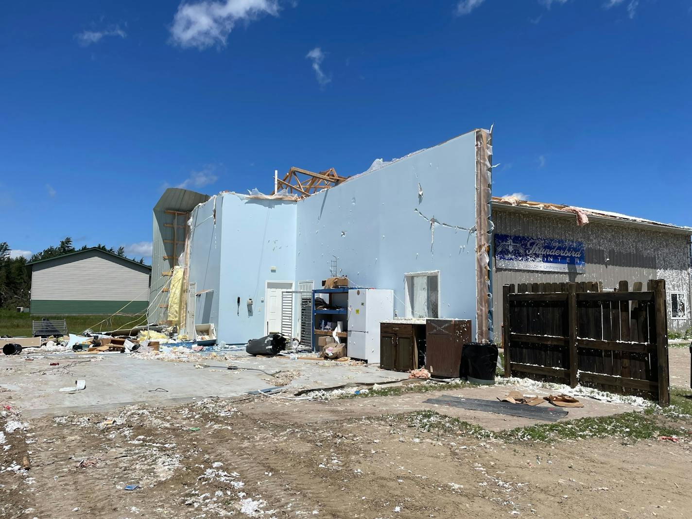
BEMIDJI - Just a day after devastating straight-line winds caused a state of emergency here, another tornado warning blanketed much of northwest Minnesota on Sunday night.

Tornadoes touched down around 7 p.m. near the small town of Grygla, 40 miles east of Thief River Falls and 30 mile west of Upper Red Lake. Tornadoes were also spotted in northern Beltrami County, which declared a state of emergency along with the city of Bemidji on Saturday in the aftermath of a storm that was the equivalent of a Category 3 hurricane. Around 27,000 were without power Saturday. More than 6,500 were still without it Monday morning, according to outage maps for Otter Tail Power and Beltrami Electric.

Thankfully, no injuries or structural damage were reported with the tornadoes Sunday, said Tim Kaiser, warning coordination meteorologist with the National Weather Service in Grand Forks, N.D.

“As much as we know, and it’s pretty early, especially given the ruralness of that area, it was just open field, bog touchdowns,” Kaiser said in an interview Monday. “And it was like an intermittent one or two times the tornado touched down as it kind of moved across that northwest portion of Beltrami into southern Lake of the Woods.”

The headquarters for Thunderbird Graphics, a longtime Bemidji business that makes trophies and customizes shirts and jackets, was totaled in the weekend storm. (Kim Hyatt/The Minnesota Star Tribune)

Beltrami County Emergency Management shared an update Sunday on Facebook: “UGH.. TORNADO WATCH,” which spoke to the disbelief and exhaustion of back-to-back days of severe weather in the region.

The NWS quickly upgraded the watch to a tornado warning for Grygla and the northwest corner of Beltrami.

“It’s hard to adjust to after not having that type of weather for much of the year, and then when summer flips the switch, we get the potential for those significant severe storms,” Kaiser said.

A cold front is bringing a much-needed reprieve to the area that also saw extreme heat Sunday nearing 90 degrees. Crews and homeowners busy with cleanup and restoration efforts welcomed Monday’s cooler temps. The Salvation Army had set up a disaster response center at the Sanford Center in Bemidji and was sending mobile food vehicles to provide “food, hydration, clean-up kits and emotional and spiritual care” to workers residents and volunteers.

“We’re working to provide needed meals to all those who have suffered damage to their homes or businesses and need help,” said Dorothy Maples, The Salvation Army Twin Cities director of Emergency Disaster Services. “We arrived early on Sunday morning and will be here for as long as people have a need.

In every Bemidji neighborhood the buzz of chainsaws echoed. Piles of freshly stacked wood lined driveways and sidewalks. At coffeeshops, grocery stores and restaurants, the chatter was all about the storm, how it could’ve been worse, what damage people experienced, how it’s a miracle no one died.

Trucks hauling trailers loaded down with branches and stumps a common sight.

It will take days if not weeks to get electricity up and running in rural areas, and even longer to fully clean up the mess. But even then, residents and Bemidji Mayor Jorge Prince say the city will never be the same after the storm.

Stands of trees are gone across the region, most strikingly in all the parks surrounding Lake Bemidji. Thousands lay in neighborhoods and pastures, every single tree pointing east, a sign of the straight-line winds that Kaiser said can be even more destructive than a tornado.

“That footprint of damage is typically wider than when a tornado does move through,” he said.

“It’s easier to understand the damage when it’s a tornado. I think mentally for us, we don’t quite understand how just winds can do that, but it is obviously capable.”

Straight-line wind damage is more common for this part of the world than tornado damage; Kaiser likened such winds to a leaf blower, rather than a spinning vortex.

The NWS is requesting satellite data when skies clear to understand the footprint of the blowdown, where it began, the width and the end.

Kaiser said the investigation into the destructive storm will go on for weeks, perhaps even months.

Beltrami County Emergency Management shared an update Monday morning, noting that the Bemidji post office is closed with “extremely limited” rural delivery and limited city delivery. Plans are underway for a parcel pickup.

The transfer station and landfill are seeing unprecedented congestion from homeowners dropping off trees and debris. Officials urge patience and remind private property owners outside city limits that they are responsible for removal.

The Bemidji Fire Department said city curbside tree debris pickup will start Monday. Residents can bring leaves, branches and logs to the nearest street for pickup. No construction debris or stumps will be collected.

The Red Cross closed its overnight shelter at the Sanford Center as displaced residents returned to pre-disaster accommodations or made alternative arrangements, emergency management said. The Red Cross station will remain open from 8 a.m. to 6 p.m. through Wednesday for essential supplies, food and water.

This is the peak for Minnesota’s severe weather, beginning the middle of June to the first of August. Because there is more moisture in the air and we’re not experiencing a drought like this time last year, Kaiser said conditions are ripe for thunderstorms and tornadoes.

The window of severe weather is smaller, and Kaiser said residents need to be prepared at home or on vacation.

“Lots of people at the lakes and cabins have to have a way to receive that weather information,” he said. “Mother Nature did remind us what it can do now. So it’s imperative going forward to have a way to receive your warnings. Have a plan. Have a shelter available.”

He said the cold front is stabilizing the air the first half of this week, but a more active weather pattern returns by Thursday, with the chance for thunderstorms over the weekend.

about the writer

about the writer

Kim Hyatt

Reporter

Kim Hyatt reports on North Central Minnesota. She previously covered Hennepin County courts.

See Moreicon